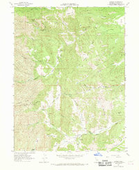
1967 Map of Lowrey
USGS Topo · Published 1969About this map
Lowrey is the primary focus of this late-1960s survey, situated along the North Fork Elder Creek in western Tehama County. The map provides a detailed view of the rural infrastructure of the era, from the small Lowrey Cem to the remote Landing Strip and Gaging Station that supported local ranching and water management. The landscape is defined by its drainage systems, including Red Bank Creek and the South Fork Elder Creek, which cut through numerous named flats and hollows like Bluedoor Flat and Hungry Hollow.
Find a feature on this map
41 named features on this map. Tap any name to fly to it.
Don’t see what you’re looking for? This feature index may not catch every label — zoom into the map to look around manually.
Map Details
Editions of this 1967 Lowrey Map
This is the sole edition of this map. No revisions or reprints were ever made.
Other maps of this area

1890 · Red Bluff
USGS Topo · 1:250,000

1894 · Red Bluff
USGS Topo · 1:250,000

1944 · Flournoy
USGS Topo · 1:62,500

1949 · Colyear Springs
USGS Topo · 1:62,500

1952 · Blossom
USGS Topo · 1:24,000

1952 · Red Bank
USGS Topo · 1:24,000

1952 · Paskenta
USGS Topo · 1:62,500

1952 · Red Bank
USGS Topo · 1:62,500

1957 · Colyear Springs
USGS Topo · 1:62,500

1957 · Ukiah
USGS Topo · 1:250,000