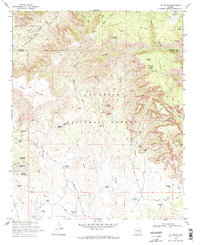
1970 Map of Loy Butte
USGS Topo · Published 1972About this map
Cliff Dwelling remains and Ruins dot the landscape of the Red Rock country in the early 1970s, where the high plateaus of Coconino National Forest meet the canyons of the Prescott National Forest. This era shows a network of remote ranching outposts and water management features essential for livestock in the arid terrain, including Hancock Ranch and Red Canyon Ranch. The map reveals a transition from historical wilderness habitation to a more managed forest landscape, evidenced by numerous isolated structures such as Taylor Cabin, Buck Ridge Cabin, and Secret Cabin. Extensive drainage systems like Sycamore Canyon and Loy Canyon define the topography, while man-made water sources like Robbers Roost Tank and Grindstone Tank highlight the necessity of reliable water for both ranchers and early forest rangers navigating the many Pack Trails and Jeep Trails.
Find a feature on this map
67 named features on this map. Tap any name to fly to it.
Don’t see what you’re looking for? This feature index may not catch every label — zoom into the map to look around manually.
Map Details
Editions of this 1970 Loy Butte Map
2 editions found
Other maps of this area

1886 · San Francisco Mtns
USGS Topo · 1:250,000

1886 · Chino
USGS Topo · 1:250,000

1887 · Verde
USGS Topo · 1:250,000

1887 · Prescott
USGS Topo · 1:250,000

1891 · San Francisco Mtns
USGS Topo · 1:250,000

1891 · Chino
USGS Topo · 1:250,000

1892 · Verde
USGS Topo · 1:250,000

1892 · Prescott
USGS Topo · 1:250,000

1894 · San Francisco Mtns
USGS Topo · 1:250,000

1899 · San Francisco Mtns
USGS Topo · 1:250,000