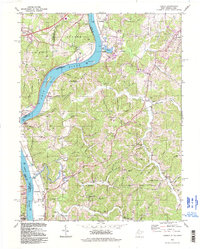
1994 Map of Lubeck
USGS Topo · Published 1998About this map
Washington Bottom and the sweeping curves of the Ohio River dominate this landscape on the West Virginia and Ohio border. The river serves as a central artery for the region, marked by navigational features like Mustapha Island and Newberry Island, as well as historic crossing points such as Harris Ferry. This mid-century topography reflects a deeply etched terrain of ridges and hollows, including Youba Ridge and Homewood Ridge, which dictated the early settlement patterns of rural communities. Genealogists will find a wealth of family history preserved in the numerous upland burial grounds, including the Newberry, Stephens, and Hupp cemeteries. Further south, the map identifies the site of Fort Belleville near the riverbank, anchoring the area's pioneer history. Local infrastructure is anchored by the community of Lubeck in the northeast, while smaller clusters like Wadeville and Hockingport appear along the river and creek valleys.
Find a feature on this map
103 named features on this map. Tap any name to fly to it.
Don’t see what you’re looking for? This feature index may not catch every label — zoom into the map to look around manually.
Map Details
Editions of this 1994 Lubeck Map
This is the sole edition of this map. No revisions or reprints were ever made.
Other maps of this area

1902 · Parkersburg
USGS Topo · 1:62,500

1904 · Parkersburg
USGS Topo · 1:62,500

1904 · Chesterhill
USGS Topo · 1:62,500

1906 · Belleville
USGS Topo · 1:62,500

1906 · Chesterhill
USGS Topo · 1:62,500

1907 · Keno
USGS Topo · 1:62,500

1924 · Belleville
USGS Topo · 1:62,500

1926 · Belleville
USGS Topo · 1:62,500

1949 · Clarksburg
USGS Topo · 1:250,000

1956 · Clarksburg
USGS Topo · 1:250,000