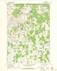
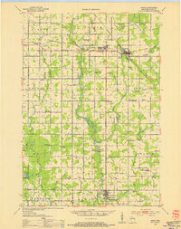
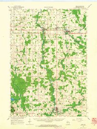
1969 Map of Lublin
USGS Topo · Published 1971About this map
The village of Lublin serves as the focal point of this late 1960s survey, situated along the Soo Line tracks near the Taylor and Clark County border. This timber and agricultural landscape is defined by its transition into the Chequamegon National Forest to the north, where Diamond Lake and Mud Lake provide a sharp contrast to the more developed sections of Roosevelt and Maplehurst townships. The local heritage is anchored by significant religious sites, including St Stanislaus Cem and St Marys Cem, which overlook the village.
Find a feature on this map
30 named features on this map. Tap any name to fly to it.
Don’t see what you’re looking for? This feature index may not catch every label — zoom into the map to look around manually.
Map Details
Editions of this 1969 Lublin Map
This is the sole edition of this map. No revisions or reprints were ever made.
Other maps of this area

1951 · Lublin
USGS Topo · 1:48,000

1951 · Gilman
USGS Topo · 1:62,500

1952 · Stanley
USGS Topo · 1:62,500
1953 · Owen
USGS Topo · 1:48,000

1953 · Eau Claire
USGS Topo · 1:250,000

1953 · Rice Lake
USGS Topo · 1:250,000

1958 · Eau Claire
USGS Topo · 1:250,000

1959 · Rice Lake
USGS Topo · 1:250,000
1963 · Owen
USGS Topo · 1:62,500

1964 · Eau Claire
USGS Topo · 1:250,000