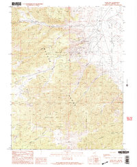
1989 Map of Lucky Boy
USGS Topo · Published 1989About this map
The Wassuk Range dominates this late 1980s landscape in Mineral County, serving as a backdrop for the extensive industrial and military footprint of the region. A notable portion of the northeastern terrain is occupied by the Hawthorne Army Ammunition Plant, indicating the long-standing military utility of this arid basin. High in the mountains, the map documents the legacy of Nevada mining at the Lucky Boy (Site) and the nearby Lucky Boy Mine.
Find a feature on this map
23 named features on this map. Tap any name to fly to it.
Don’t see what you’re looking for? This feature index may not catch every label — zoom into the map to look around manually.
Map Details
Editions of this 1989 Lucky Boy Map
2 editions found
Other maps of this area

1909 · Hawthorne
USGS Topo · 1:250,000

1911 · Hawthorne
USGS Topo · 1:250,000

1915 · Hawthorne
USGS Topo · 1:250,000

1948 · Walker Lake
USGS Topo · 1:250,000

1955 · Powell Mtn
USGS Topo · 1:62,500

1955 · Hawthorne
USGS Topo · 1:62,500

1956 · Mt. Grant
USGS Topo · 1:62,500

1956 · Aurora
USGS Topo · 1:62,500

1957 · Walker Lake
USGS Topo · 1:250,000

1962 · Walker Lake
USGS Topo · 1:250,000