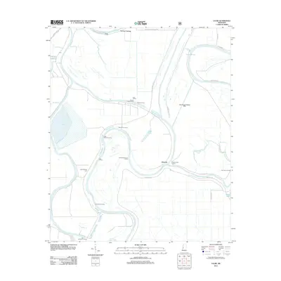
2012 Map of Lucre
USGS Topo · Published 2012About this map
Spanish Fort Landing and Harworth occupy a complex riverine environment where the Yazoo River and Big Sunflower River wind through the Mississippi Delta. This 2012 survey reveals a landscape defined by its relation to the water, featuring a dense network of specialized landings such as Madisons Woodyard Landing, Pleasant Home Landing, and Shell Mound Landing. The presence of the Yazoo Backwater Levee and the Lake George Drainage Ditch underscores the intensive water management required in this alluvial plain. Beyond the riverbanks, the map identifies significant water bodies including Lake George and Dump Lake, alongside managed areas like the South Greentree Reservoir. The road network, including Spanish Fort Rd and Whittington W Levee Rd, follows the natural and artificial high ground created by the river's levees and embankments.
Find a feature on this map
40 named features on this map. Tap any name to fly to it.
Don’t see what you’re looking for? This feature index may not catch every label — zoom into the map to look around manually.
Map Details
Editions of this 2012 Lucre Map
This is the sole edition of this map. No revisions or reprints were ever made.
Other maps of this area

1939 · Onward
USGS Topo · 1:62,500

1939 · Lorenzen
USGS Topo · 1:62,500

1940 · Mechanicsburg
USGS Topo · 1:62,500

1955 · Jackson
USGS Topo · 1:250,000

1961 · Jackson
USGS Topo · 1:250,000

1961 · Bayland
USGS Topo · 1:62,500

1962 · Jackson
USGS Topo · 1:250,000

1963 · Mechanicsburg
USGS Topo · 1:62,500

1963 · Onward
USGS Topo · 1:62,500

1964 · Lorenzen
USGS Topo · 1:62,500