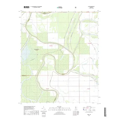
2018 Map of Lucre
USGS Topo · Published 2018About this map
Lucre sits at the northern edge of this Delta landscape, where the borders of Sharkey, Yazoo, and Issaquena counties converge. The terrain is defined by an intricate network of waterways and managed flood controls, most notably the Will M Whittington Auxiliary Channel and the Lake George Drainage Ditch. Large portions of the western half are occupied by the Delta National Forest, which is crisscrossed by specialized routes such as the 710B.5 Greentree Trail and 710A1 Clark Lake Trail. These paths navigate the seasonally flooded bottomland hardwoods surrounding Clark Lake and the Big Sunflower River. The eastern reaches show the meandering path of the Yazoo River as it winds toward the south, flanked by agricultural access roads like Dixie Farm Rd and S Dump Lake Rd, illustrating the intersection of timber conservation and Mississippi Delta farming.
Find a feature on this map
34 named features on this map. Tap any name to fly to it.
Don’t see what you’re looking for? This feature index may not catch every label — zoom into the map to look around manually.
Map Details
Editions of this 2018 Lucre Map
This is the sole edition of this map. No revisions or reprints were ever made.
Other maps of this area

1939 · Onward
USGS Topo · 1:62,500

1939 · Lorenzen
USGS Topo · 1:62,500

1940 · Mechanicsburg
USGS Topo · 1:62,500

1955 · Jackson
USGS Topo · 1:250,000

1961 · Jackson
USGS Topo · 1:250,000

1961 · Bayland
USGS Topo · 1:62,500

1962 · Jackson
USGS Topo · 1:250,000

1963 · Mechanicsburg
USGS Topo · 1:62,500

1963 · Onward
USGS Topo · 1:62,500

1964 · Lorenzen
USGS Topo · 1:62,500