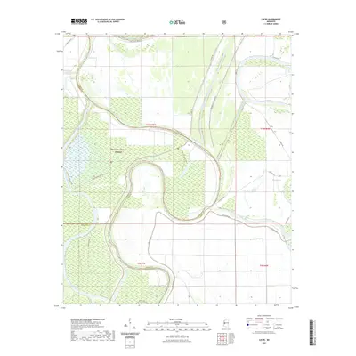
2021 Map of Lucre
USGS Topo · Published 2021About this map
The Big Sunflower River and the Yazoo River dominate this portion of the Mississippi Delta, winding through a landscape defined by water management and conservation. This survey shows the intricate network of the Will M Whittington Auxiliary Channel and the Lake George Drainage Ditch, engineering works designed to control the flow of these powerful waterways. Much of the western terrain is protected within the Delta National Forest, where the Little Sunflower River meanders near the small settlement of Lucre. This era of the Delta is marked by a complex system of levees, including the W Levee Rd and Whittington East Levee Rd, which separate agricultural tracts from the flood-prone bottomlands. Recreational and service roads like 710B S Greentree Trail and 710A1 Clark Lake Trail provide access to the interior, reflecting the modern balance between natural preservation and rural land use.
Find a feature on this map
33 named features on this map. Tap any name to fly to it.
Don’t see what you’re looking for? This feature index may not catch every label — zoom into the map to look around manually.
Map Details
Editions of this 2021 Lucre Map
This is the sole edition of this map. No revisions or reprints were ever made.
Other maps of this area

1939 · Onward
USGS Topo · 1:62,500

1939 · Lorenzen
USGS Topo · 1:62,500

1940 · Mechanicsburg
USGS Topo · 1:62,500

1955 · Jackson
USGS Topo · 1:250,000

1961 · Jackson
USGS Topo · 1:250,000

1961 · Bayland
USGS Topo · 1:62,500

1962 · Jackson
USGS Topo · 1:250,000

1963 · Mechanicsburg
USGS Topo · 1:62,500

1963 · Onward
USGS Topo · 1:62,500

1964 · Lorenzen
USGS Topo · 1:62,500