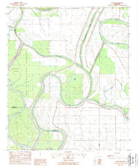
1988 Map of Lucre
USGS Topo · Published 1988About this map
Hydraulic engineering and timber management define this portion of the Mississippi Delta where the Yazoo River meets the Big Sunflower River. The landscape is a complex network of natural meanders and modern interventions, featuring the Will M Whittington Auxiliary Channel and the Lake George Drainage Ditch, both designed to manage the flood-prone bottomlands. Much of the western territory is preserved within the Delta National Forest, including the South Greentree Reservoir and the Six Mile Cut-Off. Local settlement is sparse, centered around the small communities of Lucre and Cypress. Numerous wells and the Dick Lake Air Strip indicate a landscape utilized for resource extraction and low-altitude aviation, while the oxbows of Lake George and Clark Lake reveal the ancient paths of the river system before modern levee and canal controls.
Find a feature on this map
21 named features on this map. Tap any name to fly to it.
Don’t see what you’re looking for? This feature index may not catch every label — zoom into the map to look around manually.
Map Details
Editions of this 1988 Lucre Map
This is the sole edition of this map. No revisions or reprints were ever made.
Other maps of this area

1939 · Onward
USGS Topo · 1:62,500

1939 · Lorenzen
USGS Topo · 1:62,500

1940 · Mechanicsburg
USGS Topo · 1:62,500

1955 · Jackson
USGS Topo · 1:250,000

1961 · Jackson
USGS Topo · 1:250,000

1961 · Bayland
USGS Topo · 1:62,500

1962 · Jackson
USGS Topo · 1:250,000

1963 · Mechanicsburg
USGS Topo · 1:62,500

1963 · Onward
USGS Topo · 1:62,500

1964 · Lorenzen
USGS Topo · 1:62,500