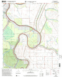
2000 Map of Lucre
USGS Topo · Published 2002About this map
Lucre sits at the northern edge of this Delta landscape, where the confluence of major waterways defines the local geography. The map documents the intricate winding of the Yazoo River as it meets the Big Sunflower River and the Little Sunflower River along the borders of Sharkey, Yazoo, and Issaquena counties. Extensive levee systems, including the Road on Levee, trace these banks, indicating a territory shaped by flood control and drainage management at the turn of the millennium.
Find a feature on this map
26 named features on this map. Tap any name to fly to it.
Don’t see what you’re looking for? This feature index may not catch every label — zoom into the map to look around manually.
Map Details
Editions of this 2000 Lucre Map
This is the sole edition of this map. No revisions or reprints were ever made.
Other maps of this area

1939 · Onward
USGS Topo · 1:62,500

1939 · Lorenzen
USGS Topo · 1:62,500

1940 · Mechanicsburg
USGS Topo · 1:62,500

1955 · Jackson
USGS Topo · 1:250,000

1961 · Jackson
USGS Topo · 1:250,000

1961 · Bayland
USGS Topo · 1:62,500

1962 · Jackson
USGS Topo · 1:250,000

1963 · Mechanicsburg
USGS Topo · 1:62,500

1963 · Onward
USGS Topo · 1:62,500

1964 · Lorenzen
USGS Topo · 1:62,500