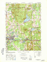
1947 Map of Ludlow
USGS Topo · Published 1947About this map
The Chicopee River carves a central path through this post-war landscape, serving as the industrial and geographic anchor for Ludlow and Indian Orchard. This 1947 survey captures the region as its mill-town character integrated with expanding residential and recreational spaces, notably the Ludlow Country Club and the high-elevation Springfield Reservoir. The transportation network is dominated by the Boston and Albany Railroad and the Boston and Maine RR, which parallel the river and connect the manufacturing hubs of the valley.
Find a feature on this map
61 named features on this map. Tap any name to fly to it.
Don’t see what you’re looking for? This feature index may not catch every label — zoom into the map to look around manually.
Map Details
Editions of this 1947 Ludlow Map
This is the sole edition of this map. No revisions or reprints were ever made.
Other maps of this area

1885 · Northampton
USGS Topo · 1:62,500

1886 · Springfield
USGS Topo · 1:62,500

1886 · Northampton
USGS Topo · 1:62,500

1887 · Palmer
USGS Topo · 1:62,500

1887 · Belchertown
USGS Topo · 1:62,500

1889 · Springfield
USGS Topo · 1:62,500

1889 · Palmer
USGS Topo · 1:62,500

1890 · Belchertown
USGS Topo · 1:62,500

1891 · Northampton
USGS Topo · 1:62,500

1893 · Northampton
USGS Topo · 1:62,500