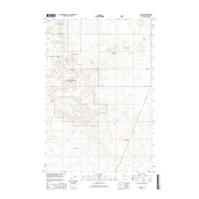
2015 Map of Ludlow
USGS Topo · Published 2015About this map
Custer National Forest dominates the western half of this Harding County landscape, centering on the prominent North Cave Hills and the strategically positioned Riley Pass. This region is defined by its complex network of seasonal drainages and human-made water management features, including High-and-Dry Reservoir, Schleichart Draw Reservoir, and Ash Tree Reservoir, which support livestock and land use in this arid environment. The small settlement of Ludlow sits on the eastern edge of the quadrangle, serving as a landmark in a terrain otherwise marked by named natural features like Rileys Butte and the Flint Hills. The presence of numerous named springs, such as Jenkins Spring Number One and Paddalower Spring, indicates the vital importance of water sources in the high plains ranching economy of the twenty-first century.
Find a feature on this map
41 named features on this map. Tap any name to fly to it.
Don’t see what you’re looking for? This feature index may not catch every label — zoom into the map to look around manually.
Map Details
Editions of this 2015 Ludlow Map
This is the sole edition of this map. No revisions or reprints were ever made.
Other maps of this area
1935 · Reva
USGS Topo · 1:125,000
1935 · Buffalo
USGS Topo · 1:125,000
1954 · Lemmon
USGS Topo · 1:250,000
1957 · Lemmon
USGS Topo · 1:250,000
1968 · Eagles Nest Butte
USGS Topo · 1:24,000
1968 · Ludlow
USGS Topo · 1:24,000
1968 · Tepee Buttes
USGS Topo · 1:24,000
1968 · Ludlow SE
USGS Topo · 1:24,000
1969 · Ladner NE
USGS Topo · 1:24,000
1969 · Ladner SE
USGS Topo · 1:24,000