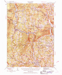
1929 Map of Ludlow
USGS Topo · Published 1969About this map
The Black River and the Rutland railroad corridor anchor this late 1920s survey of south-central Vermont. The landscape is defined by its industrial and agricultural valley towns, including Ludlow, Proctorsville, and Cavendish, where the river drops through the Cavendish Gorge. This era shows a densely settled rural landscape, with dozens of one-room schoolhouses such as the Sawyer Stand School and Old Shincracker serving remote upland districts like Plymouth Kingdom. The inclusion of the Springfield Airport near North Springfield marks the early 20th-century modernization of the region alongside traditional post offices like Felchville Reading P O. Notable mountain gaps, identified here as Proctorsville Gulf and Duttonsville Gulf, provide natural passage for travel through the steep terrain of Hawks Mountain and Ludlow Mountain.
Find a feature on this map
149 named features on this map. Tap any name to fly to it.
Don’t see what you’re looking for? This feature index may not catch every label — zoom into the map to look around manually.
Map Details
Editions of this 1929 Ludlow Map
2 editions found

Other maps of this area

1891 · Rutland
USGS Topo · 1:62,500

1893 · Wallingford
USGS Topo · 1:62,500

1893 · Rutland
USGS Topo · 1:62,500

1894 · Londonderry
USGS Topo · 1:62,500

1899 · Londonderry
USGS Topo · 1:62,500

1906 · Hanover
USGS Topo · 1:62,500

1908 · Hanover
USGS Topo · 1:62,500

1911 · Woodstock
USGS Topo · 1:62,500

1913 · Woodstock
USGS Topo · 1:62,500

1926 · Claremont
USGS Topo · 1:62,500