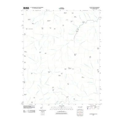
2010 Map of Luftee Knob
USGS Topo · Published 2010About this map
Luftee Knob and the surrounding high ridges of Haywood County define this landscape along the North Carolina and Tennessee border. The terrain is characterized by a dense network of watercourses, including the headwaters of Big Creek, Gunter Fork, and Cosby Creek, which drain the steep slopes of Snake Den Mountain and Camel Hump Mountain. Low-lying areas like Walnut Bottom and Poplar Cove offer rare breaks in the elevation, while prominent points such as Mount Yonaguska and Mount Hardison mark the crests of the Great Smoky Mountains. This survey preserves the location of traditional passage points through the high country, including Yellow Creek Gap, Camel Gap, and Laurel Gap, which historically facilitated movement across these formidable peaks. The presence of Mouse Creek Falls and various named branches highlights the area's complex hydrology before further modern development altered these remote wilderness drainages.
Find a feature on this map
95 named features on this map. Tap any name to fly to it.
Don’t see what you’re looking for? This feature index may not catch every label — zoom into the map to look around manually.
Map Details
Editions of this 2010 Luftee Knob Map
This is the sole edition of this map. No revisions or reprints were ever made.
Other maps of this area

1893 · Mt Guyot
USGS Topo · 1:125,000

1912 · Mt Guyot
USGS Topo · 1:125,000

1935 · Newport
USGS Topo · 1:48,000

1935 · Hartford
USGS Topo · 1:24,000

1935 · English Mountain
USGS Topo · 1:48,000

1935 · Dellwood
USGS Topo · 1:24,000

1935 · Jones Cove
USGS Topo · 1:24,000

1936 · Bunches Bald
USGS Topo · 1:24,000
1936 · Cove Creek Gap
USGS Topo · 1:24,000
1936 · Waterville
USGS Topo · 1:24,000