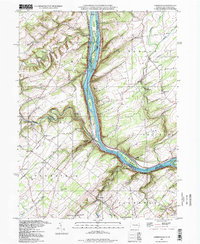
1997 Map of Lumberville
USGS Topo · Published 1998About this map
Delaware River islands and high bluffs define this borderland between Pennsylvania and New Jersey. The steep topography of the river corridor is punctuated by features like Devils Tea Table and Tumble Falls, while the plateau above supports a network of rural hamlets including Lumberville, Point Pleasant, and Erwinna. Local history is deeply etched into the landscape through institutions like Brick Church Sch, Tahicken Hill Sch, and Kingwood Ch.
Find a feature on this map
82 named features on this map. Tap any name to fly to it.
Don’t see what you’re looking for? This feature index may not catch every label — zoom into the map to look around manually.
Map Details
Editions of this 1997 Lumberville Map
This is the sole edition of this map. No revisions or reprints were ever made.
Other maps of this area

1890 · Easton
USGS Topo · 1:62,500

1890 · High Bridge
USGS Topo · 1:62,500

1890 · Lambertville
USGS Topo · 1:62,500

1890 · Doylestown
USGS Topo · 1:62,500

1891 · Easton
USGS Topo · 1:62,500

1891 · Lambertville
USGS Topo · 1:62,500

1891 · Doylestown
USGS Topo · 1:62,500

1894 · Lambertville
USGS Topo · 1:62,500

1898 · High Bridge
USGS Topo · 1:62,500

1900 · Raritan
USGS Topo · 1:125,000
Featured Places
- Buckingham Township, PA
- Solebury Township, PA
- Bedminster Township, PA
- Tinicum Township, PA
- Kingwood Township, NJ