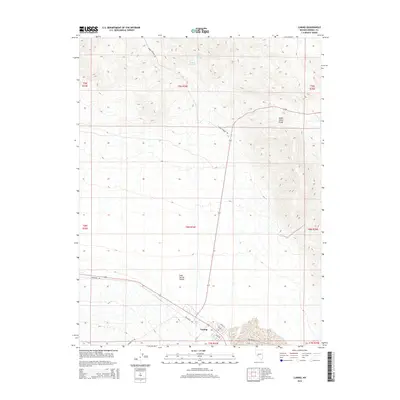
2014 Map of Luning
USGS Topo · Published 2014About this map
Luning sits at the junction of desert transit and mountainous terrain, anchoring a landscape where the Soda Spring Valley meets the southern elevations of the Gabbs Valley Range. This Mineral County settlement is organized around a traditional grid featuring Elite St, Galena St, and Nevada St, reflecting its historical role as a local crossroads. The surrounding geography is defined by its arid character, marked by essential water sources like Benton Spring, Upper Benton Spring, and Bank Spring.
Find a feature on this map
22 named features on this map. Tap any name to fly to it.
Don’t see what you’re looking for? This feature index may not catch every label — zoom into the map to look around manually.
Map Details
Editions of this 2014 Luning Map
This is the sole edition of this map. No revisions or reprints were ever made.
Other maps of this area

1909 · Hawthorne
USGS Topo · 1:250,000

1911 · Hawthorne
USGS Topo · 1:250,000

1915 · Hawthorne
USGS Topo · 1:250,000

1948 · Walker Lake
USGS Topo · 1:250,000

1957 · Walker Lake
USGS Topo · 1:250,000

1962 · Walker Lake
USGS Topo · 1:250,000

1964 · Walker Lake
USGS Topo · 1:250,000

1967 · Mina NW
USGS Topo · 1:24,000
1967 · Mina
USGS Topo · 1:24,000
1967 · Mable Mountain
USGS Topo · 1:24,000