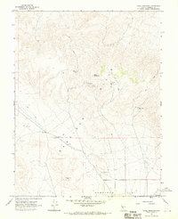
1967 Map of Mable Mountain
USGS Topo · Published 1970About this map
Mable Mountain anchors this high-desert mining landscape within the Garfield Hills during the late 1960s. The map reveals an active network of industrial extraction, marked by several significant mining sites including the Mable Mine, Garfield Mine, and Bluelight Mine. These operations are connected by a web of Jeep Trails and primitive roads that navigate the complex topography, indicating a period of continued mineral exploration in Mineral County. To the south, the terrain descends into the expansive Garfield Flat, where a massive area of Sand Dunes and the Rock Cabin Mine highlight the shift from the uplifted hills to the basin floor. The presence of an Alkali Flat and a solitary Water Tank in the northwest further emphasizes the arid character of this remote Nevada interior, providing a clear record of the specialized land use required to sustain mining efforts in such a dry environment.
Find a feature on this map
21 named features on this map. Tap any name to fly to it.
Don’t see what you’re looking for? This feature index may not catch every label — zoom into the map to look around manually.
Map Details
Editions of this 1967 Mable Mountain Map
2 editions found
Other maps of this area

1909 · Hawthorne
USGS Topo · 1:250,000

1911 · Hawthorne
USGS Topo · 1:250,000

1915 · Hawthorne
USGS Topo · 1:250,000

1948 · Walker Lake
USGS Topo · 1:250,000

1957 · Walker Lake
USGS Topo · 1:250,000

1962 · Walker Lake
USGS Topo · 1:250,000

1964 · Walker Lake
USGS Topo · 1:250,000

1967 · Pamlico
USGS Topo · 1:24,000

1967 · Moho Mountain
USGS Topo · 1:24,000

1967 · Mina NW
USGS Topo · 1:24,000