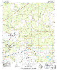
1994 Map of Lunita
USGS Topo · Published 1996About this map
The Houston River and its meandering tributaries dominate this Calcasieu Parish landscape, where the rural settlements of Lunita and Lucas sit north of the major watercourse. The area reflects a complex water management and industrial history, evidenced by the large Sabine River Diversion System cutting across the southern half of the quadrangle, flanked by extensive Levee and Pipeline infrastructure. Local history and genealogy are anchored by two primary burial grounds: Benevolent Cem near the western edge and Big Woods Cem to the southeast, which serves the community of Big Woods. The terrain transitions from the low-lying drainage of Persimmon Gully and Coon Gully into the higher ground where a small Landing Strip and communication towers indicate the modern utility of the land in the mid-1990s.
Find a feature on this map
17 named features on this map. Tap any name to fly to it.
Don’t see what you’re looking for? This feature index may not catch every label — zoom into the map to look around manually.
Map Details
Editions of this 1994 Lunita Map
This is the sole edition of this map. No revisions or reprints were ever made.
Other maps of this area

1932 · Orange
USGS Topo · 1:62,500

1947 · Sulphur
USGS Topo · 1:31,680

1947 · Starks
USGS Topo · 1:31,680

1947 · Vinton
USGS Topo · 1:31,680

1947 · Toomey
USGS Topo · 1:31,680

1947 · Carter Creek
USGS Topo · 1:31,680

1947 · DeQuincy
USGS Topo · 1:31,680

1947 · Sulphur Mines
USGS Topo · 1:31,680

1947 · Lunita
USGS Topo · 1:31,680

1947 · Long Marsh
USGS Topo · 1:31,680