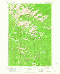
1964 Map of Lupine Creek
USGS Topo · Published 1967About this map
Lolo National Forest dominates this mid-1960s survey of the divide between Mineral and Missoula counties. The landscape is defined by an intricate network of drainage systems, with Burdette Creek and Lupine Creek carving through the western slopes while the South Fork Petty Creek and Johns Creek flow to the east. This era shows a forest managed through a legacy of primitive transportation, visible in the numerous labels for a Pack Trail and a Jeep Trail that traverse the high ridges.
Find a feature on this map
20 named features on this map. Tap any name to fly to it.
Don’t see what you’re looking for? This feature index may not catch every label — zoom into the map to look around manually.
Map Details
Editions of this 1964 Lupine Creek Map
This is the sole edition of this map. No revisions or reprints were ever made.
Other maps of this area

1911 · Lolo
USGS Topo · 1:250,000

1912 · Missoula
USGS Topo · 1:125,000

1913 · Lolo
USGS Topo · 1:250,000

1956 · Hamilton
USGS Topo · 1:250,000

1959 · Hamilton
USGS Topo · 1:250,000

1960 · Hamilton
USGS Topo · 1:250,000

1964 · Hamilton
USGS Topo · 1:250,000

1964 · Lolo Hot Springs
USGS Topo · 1:24,000

1964 · Garden Point
USGS Topo · 1:24,000

1964 · West Fork Butte
USGS Topo · 1:24,000