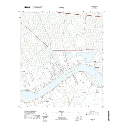
2020 Map of Lutcher
USGS Topo · Published 2020About this map
The Mississippi River carves a deep arc through this section of the river parishes, defining the growth of Lutcher and Gramercy along its northern bank. This landscape is characterized by the tight ribbon of development following the river's course, where historic landing points like Grandview Reach and Fifty-mile Point served as vital conduits for the regional economy. Beyond the immediate riverfront, the map details an extensive network of waterways and drainage, including the Colonial Canal and Lutcher Canal, which give way to the wetlands of the St. James Parish interior. Several significant burial sites, such as the Saint Philip Cem and Mausoleum and Western Cem, anchor the residential communities. On the southern bank, the settlement of Vacherie and North Vacherie follow a similar linear pattern, illustrating how the river's geography dictated the placement of roads like La 18 and long-standing family-named thoroughfares.
Find a feature on this map
116 named features on this map. Tap any name to fly to it.
Don’t see what you’re looking for? This feature index may not catch every label — zoom into the map to look around manually.
Map Details
Editions of this 2020 Lutcher Map
This is the sole edition of this map. No revisions or reprints were ever made.
Other maps of this area

1892 · Lac Des Allemands
USGS Topo · 1:62,500

1892 · Mount Airy
USGS Topo · 1:62,500

1892 · Donaldsonville
USGS Topo · 1:62,500

1892 · Thibodaux
USGS Topo · 1:62,500

1932 · Lac Des Allemands NW
USGS Topo · 1:31,680

1932 · Thibodaux NE
USGS Topo · 1:31,680

1932 · Lac Des Allemands NE
USGS Topo · 1:31,680

1939 · Donaldsonville
USGS Topo · 1:62,500

1940 · Lagan
USGS Topo · 1:31,680
1941 · Lac Des Allemands
USGS Topo · 1:62,500