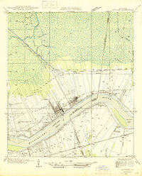
1946 Map of Lutcher
USGS Topo · Published 1946About this map
The Mississippi River defines the landscape of this riverfront corridor, where the Grand View Reach and Willow Bend shape the surrounding agricultural and industrial development. The region's economic foundation in sugar production is clearly marked by the Longview Sugar Mill near Paulina and the Evergreen Sugar Mill further downstream, reflecting the plantation-style land divisions that radiate back from the riverbanks.
Find a feature on this map
38 named features on this map. Tap any name to fly to it.
Don’t see what you’re looking for? This feature index may not catch every label — zoom into the map to look around manually.
Map Details
Editions of this 1946 Lutcher Map
This is the sole edition of this map. No revisions or reprints were ever made.
Other maps of this area

1892 · Lac Des Allemands
USGS Topo · 1:62,500

1892 · Mount Airy
USGS Topo · 1:62,500

1892 · Donaldsonville
USGS Topo · 1:62,500

1892 · Thibodaux
USGS Topo · 1:62,500

1932 · Lac Des Allemands NW
USGS Topo · 1:31,680

1932 · Thibodaux NE
USGS Topo · 1:31,680

1932 · Lac Des Allemands NE
USGS Topo · 1:31,680

1939 · Donaldsonville
USGS Topo · 1:62,500

1940 · Lagan
USGS Topo · 1:31,680
1941 · Lac Des Allemands
USGS Topo · 1:62,500