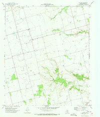
1971 Map of Luther
USGS Topo · Published 1973About this map
Luther Oil Field dominates the landscape of Howard County in the early 1970s, defined by a network of drilling infrastructure and resource extraction. The small community of Luther serves as a central point in this industrial landscape, where the flat Texas terrain is crisscrossed by an extensive Pipeline network and a large Aqueduct in the southeast corner. Despite the industrial overlay, signs of rural community life remain visible at Gay Hill Sch and Bethel Ch. The drainage patterns of the Llano Estacado are clearly etched into the topography through features like Dorward Draw and the winding course of Wildcat Creek. This survey captures the region as a mature energy-producing territory, balanced between its original ranching character and the modern demands of water management and oil production.
Find a feature on this map
19 named features on this map. Tap any name to fly to it.
Don’t see what you’re looking for? This feature index may not catch every label — zoom into the map to look around manually.
Map Details
Editions of this 1971 Luther Map
This is the sole edition of this map. No revisions or reprints were ever made.
Other maps of this area

1942 · Big Spring North
USGS Topo · 1:62,500

1954 · Big Spring
USGS Topo · 1:250,000

1954 · Big Spring North
USGS Topo · 1:24,000

1954 · Big Spring North NE
USGS Topo · 1:24,000

1958 · Big Spring
USGS Topo · 1:250,000

1965 · Big Spring North
USGS Topo · 1:24,000

1966 · Knott SE
USGS Topo · 1:24,000

1966 · Knott NE
USGS Topo · 1:24,000

1970 · Vealmoor
USGS Topo · 1:24,000
1970 · Gunsight Draw
USGS Topo · 1:24,000