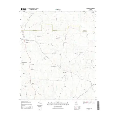
2014 Map of Luthersville
USGS Topo · Published 2014About this map
The Georgia piedmont at the Coweta and Meriwether county line is characterized by a high concentration of family-named roads and rural settlements. Luthersville serves as the primary hub, where Railroad St and Ga-41 intersect, reflecting the community's historical reliance on transportation. To the southeast, the crossroads at Rocky Mount and Wooster anchoring the landscape alongside agricultural tracts. A network of small waterways, including Panther Cr and Red Oak Cr, defines the local drainage patterns. Researchers will find significant genealogical value in the numerous small burial grounds such as Hannah Cem, Strickland Town Cem, and Dunlap Cem. These sites, often positioned near family landholdings like those along Melvin Mitchell Rd or Mc Williams Barber Rd, provide a window into the settlement history of these rural districts in the early 21st century.
Find a feature on this map
87 named features on this map. Tap any name to fly to it.
Don’t see what you’re looking for? This feature index may not catch every label — zoom into the map to look around manually.
Map Details
Editions of this 2014 Luthersville Map
This is the sole edition of this map. No revisions or reprints were ever made.
Other maps of this area

1953 · Atlanta
USGS Topo · 1:250,000

1957 · Atlanta
USGS Topo · 1:250,000

1958 · Atlanta
USGS Topo · 1:250,000

1964 · Grantville
USGS Topo · 1:24,000
1964 · Odessadale
USGS Topo · 1:24,000

1965 · Newnan South
USGS Topo · 1:24,000

1965 · Senoia
USGS Topo · 1:24,000

1965 · Sharpsburg
USGS Topo · 1:24,000
1971 · Luthersville
USGS Topo · 1:24,000
1971 · Greenville
USGS Topo · 1:24,000