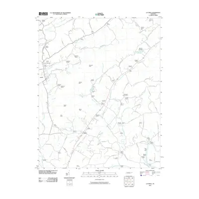
2010 Map of Luttrell
USGS Topo · Published 2010About this map
Luttrell and Blaine anchor this 2010 topographic study, which highlights a landscape shaped by both the Holston River and the industrial activity of the Republic Quarry. The mapping reveals a dense network of family history and community origins through its numerous burial grounds, including the Jarnagin Cemetery, Lea Springs Cemetery, and Shipe Cemetery. Notable topographical landmarks such as Signal Point and Rhetts View overlook the valleys of Flat Creek and Richland Creek. Along the southern border, the river's influence is evident at Nancès Shoals and the historical crossing at Mitchell Ford. The presence of several hollows, like Stillhouse Hollow and Jimtown Hollow, suggests a history of localized settlement and early Appalachian industry tucked into the ridgelines.
Find a feature on this map
121 named features on this map. Tap any name to fly to it.
Don’t see what you’re looking for? This feature index may not catch every label — zoom into the map to look around manually.
Map Details
Editions of this 2010 Luttrell Map
This is the sole edition of this map. No revisions or reprints were ever made.
Other maps of this area

1897 · Maynardville
USGS Topo · 1:125,000

1900 · Maynardville
USGS Topo · 1:125,000

1935 · Luttrell
USGS Topo · 1:24,000

1935 · Mascot
USGS Topo · 1:24,000

1935 · Straw Plains
USGS Topo · 1:48,000

1935 · Graveston
USGS Topo · 1:24,000

1935 · Joppa
USGS Topo · 1:24,000
1935 · New Market
USGS Topo · 1:24,000

1936 · Gorryton
USGS Topo · 1:48,000

1936 · Powder Springs
USGS Topo · 1:24,000