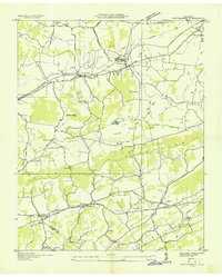
1935 Map of New Market
USGS Topo · Published 1935About this map
New Market and the surrounding East Tennessee landscape are documented here during a period of transition as the Tennessee Valley Authority began its extensive regional infrastructure projects. The settlement of New Market serves as a central hub, situated along the Southern railroad line and the primary Andrew Johnson Highway. To the north, Friends Station and Bates Sch reflect the rural community structure of Jefferson County, while the southern reaches show the influence of industrial history through sites like Dinwoody Mill, Tate Mill, and French Mill. The topography is defined by the broad corridors of Rocky Valley and Dumplin Valley, separated by the heights of Bays Mountains. Local genealogists will find significant detail in the placement of numerous country churches and schools, such as Shrader Chapel Sch near the Jefferson and Sevier county line, and the Piedmont Cem.
Find a feature on this map
59 named features on this map. Tap any name to fly to it.
Don’t see what you’re looking for? This feature index may not catch every label — zoom into the map to look around manually.
Map Details
Editions of this 1935 New Market Map
This is the sole edition of this map. No revisions or reprints were ever made.
Other maps of this area

1883 · Morristown
USGS Topo · 1:125,000

1886 · Knoxville
USGS Topo · 1:125,000

1892 · Knoxville
USGS Topo · 1:125,000

1893 · Mt Guyot
USGS Topo · 1:125,000

1893 · Morristown
USGS Topo · 1:125,000

1894 · Knoxville
USGS Topo · 1:125,000

1895 · Morristown
USGS Topo · 1:125,000

1895 · Knoxville
USGS Topo · 1:125,000

1897 · Maynardville
USGS Topo · 1:125,000

1900 · Maynardville
USGS Topo · 1:125,000