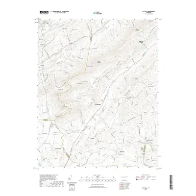
2019 Map of Luttrell
USGS Topo · Published 2019About this map
Clinch Mountain and the surrounding valleys of East Tennessee define the landscape of this 2019 survey, where rural communities like Blaine and Luttrell are linked by historic corridors such as Rutledge Pike. The map provides a detailed view of the ridges and coves that have shaped settlement patterns for generations, including Poor Valley and Richland Valley. Genealogical interest is high throughout the quadrangle, with numerous small burial grounds like Mynatt Cem, Lea Springs Cem, and the Mouth of Richland Cem near the Holston River. Settlement clusters such as Chesney and Zacharytown are shown alongside landmarks like Melton Field and the Race Track Bluff, illustrating the continued importance of both the land and its historic water sources, including Sulphur Spring and Heatherly Spring.
Find a feature on this map
174 named features on this map. Tap any name to fly to it.
Don’t see what you’re looking for? This feature index may not catch every label — zoom into the map to look around manually.
Map Details
Editions of this 2019 Luttrell Map
This is the sole edition of this map. No revisions or reprints were ever made.
Other maps of this area

1897 · Maynardville
USGS Topo · 1:125,000

1900 · Maynardville
USGS Topo · 1:125,000

1935 · Luttrell
USGS Topo · 1:24,000

1935 · Mascot
USGS Topo · 1:24,000

1935 · Straw Plains
USGS Topo · 1:48,000

1935 · Graveston
USGS Topo · 1:24,000

1935 · Joppa
USGS Topo · 1:24,000
1935 · New Market
USGS Topo · 1:24,000

1936 · Gorryton
USGS Topo · 1:48,000

1936 · Powder Springs
USGS Topo · 1:24,000