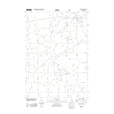
2012 Map of Luzerne
USGS Topo · Published 2012About this map
Luzerne serves as the primary settlement center on this 2012 survey, situated near the confluence of the W Br Big Cr and E Br Big Cr. This portion of Oscoda County is defined by its extensive drainage network and recreational sites, including the Luzerne Campground and Luzerne Trail Camp. The landscape transitions from the developed cluster near Luzerne Pond to the higher elevations of Mount Pindus in the south. Genealogists will find three distinct burial grounds: Luzerne Cem in the north, and Mount Pindus Cem and Rich Cem located further south. The map also documents fire management and forestry infrastructure through the Luzerne Lookout Tower and the Luzerne Fire Point of Interest, reflecting the area's ongoing relationship with the surrounding forest lands.
Find a feature on this map
46 named features on this map. Tap any name to fly to it.
Don’t see what you’re looking for? This feature index may not catch every label — zoom into the map to look around manually.
Map Details
Editions of this 2012 Luzerne Map
This is the sole edition of this map. No revisions or reprints were ever made.
Other maps of this area

1954 · Traverse City
USGS Topo · 1:250,000

1958 · Traverse City
USGS Topo · 1:250,000

1963 · Luzerne
USGS Topo · 1:24,000

1963 · Eldorado
USGS Topo · 1:24,000
1963 · Luzerne NW
USGS Topo · 1:24,000

1963 · Red Oak
USGS Topo · 1:24,000

1965 · Damon
USGS Topo · 1:24,000

1965 · St. Helen NW
USGS Topo · 1:24,000

1965 · St. Helen NE
USGS Topo · 1:24,000

1972 · Mio
USGS Topo · 1:24,000