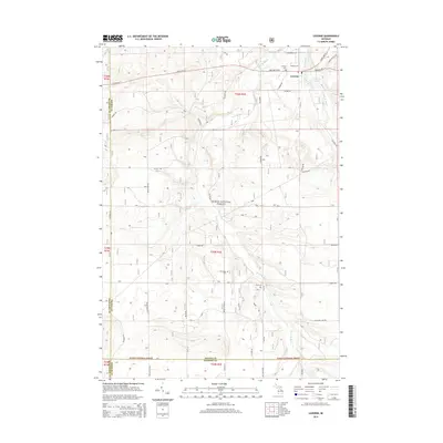
2014 Map of Luzerne
USGS Topo · Published 2014About this map
Luzerne serves as the primary hub in this northern Michigan landscape, situated at the junction of State Hwy 72 and Klammer Rd. The township character is defined by the winding waters of West Br Big Cr and its expansion into Luzerne Pond to the east. Large portions of the terrain are managed as part of the Huron National Forest, which covers much of the central and southern sections of the quadrangle. For those tracing local history, several small burial grounds are distributed across the area, including Luzerne Cem near the town center, Mt Pindus Cem near the landmark of Mt Pindus, and Rich Cem further south. The map documents a network of county and forest roads, such as Odessa Rd and S Meridian Rd, that navigate the creeks and rising terrain between Oscoda and Ogemaw counties.
Find a feature on this map
44 named features on this map. Tap any name to fly to it.
Don’t see what you’re looking for? This feature index may not catch every label — zoom into the map to look around manually.
Map Details
Editions of this 2014 Luzerne Map
This is the sole edition of this map. No revisions or reprints were ever made.
Other maps of this area

1954 · Traverse City
USGS Topo · 1:250,000

1958 · Traverse City
USGS Topo · 1:250,000

1963 · Luzerne
USGS Topo · 1:24,000

1963 · Eldorado
USGS Topo · 1:24,000
1963 · Luzerne NW
USGS Topo · 1:24,000

1963 · Red Oak
USGS Topo · 1:24,000

1965 · Damon
USGS Topo · 1:24,000

1965 · St. Helen NW
USGS Topo · 1:24,000

1965 · St. Helen NE
USGS Topo · 1:24,000

1972 · Mio
USGS Topo · 1:24,000