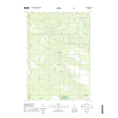
2019 Map of Luzerne
USGS Topo · Published 2019About this map
Luzerne serves as the central hub of this northern Michigan landscape, characterized by the dense woodlands of the Huron National Forest and specialized conservation zones. The village is situated near Luzerne Pond and Big Cr, with local history preserved at the Luzerne Cem. To the south, the terrain includes the Kirtlands Warbler Wildlife Management Area and Kwwma, highlighting the region's importance for rare species habitat.
Find a feature on this map
60 named features on this map. Tap any name to fly to it.
Don’t see what you’re looking for? This feature index may not catch every label — zoom into the map to look around manually.
Map Details
Editions of this 2019 Luzerne Map
This is the sole edition of this map. No revisions or reprints were ever made.
Other maps of this area

1954 · Traverse City
USGS Topo · 1:250,000

1958 · Traverse City
USGS Topo · 1:250,000

1963 · Luzerne
USGS Topo · 1:24,000

1963 · Eldorado
USGS Topo · 1:24,000
1963 · Luzerne NW
USGS Topo · 1:24,000

1963 · Red Oak
USGS Topo · 1:24,000

1965 · Damon
USGS Topo · 1:24,000

1965 · St. Helen NW
USGS Topo · 1:24,000

1965 · St. Helen NE
USGS Topo · 1:24,000

1972 · Mio
USGS Topo · 1:24,000