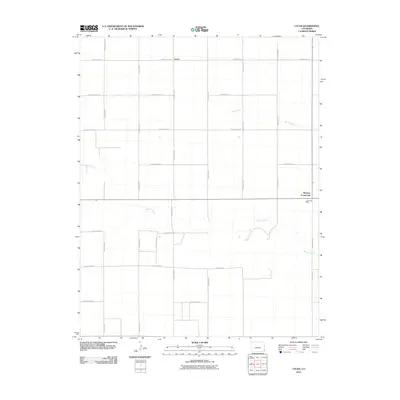
2010 Map of Lycan
USGS Topo · Published 2010About this map
Lycan and Buckeye Crossroads anchor this high plains landscape in the southeast corner of Colorado, documented during a 2010 survey by the U.S. Geological Survey. The area is defined by a rigid grid of agricultural routes, including County Road VV and County Rd-48, which segment the terrain into large parcels. This geometric order is interrupted only by the winding paths of Buffalo Creek and Beaty Creek, which provide the primary natural drainage through the territory. The presence of the Lycan Post Office at the junction of Highway 116 suggests the community's role as a local center for the surrounding ranching and farming operations in Baca County. Researchers can trace the precise location of local infrastructure and section lines that have shaped land ownership and movement in this part of the state for generations.
Find a feature on this map
20 named features on this map. Tap any name to fly to it.
Don’t see what you’re looking for? This feature index may not catch every label — zoom into the map to look around manually.
Map Details
Editions of this 2010 Lycan Map
This is the sole edition of this map. No revisions or reprints were ever made.
Other maps of this area

1891 · Albany
USGS Topo · 1:125,000

1892 · Vilas
USGS Topo · 1:125,000

1893 · Albany
USGS Topo · 1:125,000

1955 · La Junta
USGS Topo · 1:250,000

1958 · La Junta
USGS Topo · 1:250,000

1968 · La Junta
USGS Topo · 1:250,000
1971 · Lycan SE
USGS Topo · 1:24,000
1971 · Lycan NE
USGS Topo · 1:24,000
1971 · Plains Community
USGS Topo · 1:24,000

1971 · Two Buttes SE
USGS Topo · 1:24,000