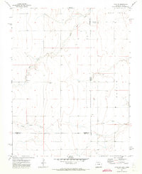
1971 Map of Lycan NE
USGS Topo · Published 1973About this map
North Bear Creek and Little Bear Creek carve a series of shallow valleys through this High Plains landscape along the Colorado-Kansas border in the early 1970s. The map illustrates a highly rural environment where the economy is driven by sparse water resources and local extraction, as evidenced by the Gravel Pit located along the northern creek branch. For genealogists and local historians, the Amerine Cem stands as a solitary landmark of early settlement in this remote corner of Prowers County. The map clearly defines the jurisdictional lines of Prowers and Stanton counties, showing how the interstate boundary bisects the drainage of Bear Creek. Numerous wells are distributed across the township blocks, highlighting the reliance on groundwater for agricultural survival in this arid prairie region.
Find a feature on this map
11 named features on this map. Tap any name to fly to it.
Don’t see what you’re looking for? This feature index may not catch every label — zoom into the map to look around manually.
Map Details
Editions of this 1971 Lycan NE Map
This is the sole edition of this map. No revisions or reprints were ever made.
Other maps of this area

1891 · Albany
USGS Topo · 1:125,000

1893 · Albany
USGS Topo · 1:125,000

1900 · Syracuse
USGS Topo · 1:125,000

1920 · Syracuse
USGS Topo · 1:125,000

1955 · La Junta
USGS Topo · 1:250,000

1955 · Dodge City
USGS Topo · 1:250,000

1958 · La Junta
USGS Topo · 1:250,000

1958 · Dodge City
USGS Topo · 1:250,000

1959 · Dodge City
USGS Topo · 1:250,000

1966 · Syracuse West SW
USGS Topo · 1:24,000