
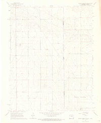
1966 Map of Syracuse West SW
USGS Topo · Published 1967About this map
Bear Creek and its tributary, North Bear Creek, dominate this Hamilton County landscape as it appeared in the mid-1960s. The terrain is defined by a series of high plains and draws, where water management and extraction are central to local life. Local landmarks like Bear Creek Cem and School No C-2 provide clear points of reference for genealogists and local historians tracking rural development in this part of Kansas. A network of unimproved dirt roads and light-duty paths connect scattered sites labeled simply as Wells or Well, indicating the critical nature of groundwater for the region's agricultural and industrial infrastructure. The presence of a Pipeline and a Gravel Pit further illustrates the intersection of natural resources and mid-century utility expansion in the high plains south of Syracuse.
Find a feature on this map
11 named features on this map. Tap any name to fly to it.
Don’t see what you’re looking for? This feature index may not catch every label — zoom into the map to look around manually.
Map Details
Editions of this 1966 Syracuse West SW Map
This is the sole edition of this map. No revisions or reprints were ever made.
Other maps of this area

1891 · Albany
USGS Topo · 1:125,000

1893 · Albany
USGS Topo · 1:125,000

1900 · Syracuse
USGS Topo · 1:125,000

1920 · Syracuse
USGS Topo · 1:125,000

1955 · La Junta
USGS Topo · 1:250,000

1955 · Dodge City
USGS Topo · 1:250,000

1958 · La Junta
USGS Topo · 1:250,000

1958 · Dodge City
USGS Topo · 1:250,000

1959 · Dodge City
USGS Topo · 1:250,000
1966 · Durkee Creek NE
USGS Topo · 1:24,000