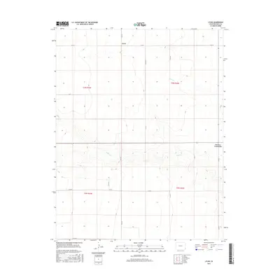
2016 Map of Lycan
USGS Topo · Published 2016About this map
Lycan and Buckeye Crossroads anchor this high plains landscape in eastern Colorado as it appeared in the mid-2010s. The terrain is defined by the ephemeral drainages of Buffalo Cr and Beaty Cr, which carve subtle relief into the expansive grid of the Public Land Survey System. The area is characterized by its meticulous sectioning, where a network of county roads follows the section lines with near-mathematical precision. Named routes such as Co Rd Vv, Co Rd Pp, and Co Rd Mm facilitate movement across this agricultural and ranching territory. This survey reflects the enduring rural character of Baca County, where the intersections at Buckeye Crossroads remain vital landmarks in an area of low-density settlement. The map serves as a detailed record of the intersections and local road systems that connect these small ranching hubs to the broader regional network.
Find a feature on this map
18 named features on this map. Tap any name to fly to it.
Don’t see what you’re looking for? This feature index may not catch every label — zoom into the map to look around manually.
Map Details
Editions of this 2016 Lycan Map
This is the sole edition of this map. No revisions or reprints were ever made.
Other maps of this area

1891 · Albany
USGS Topo · 1:125,000

1892 · Vilas
USGS Topo · 1:125,000

1893 · Albany
USGS Topo · 1:125,000

1955 · La Junta
USGS Topo · 1:250,000

1958 · La Junta
USGS Topo · 1:250,000

1968 · La Junta
USGS Topo · 1:250,000
1971 · Lycan SE
USGS Topo · 1:24,000
1971 · Lycan NE
USGS Topo · 1:24,000
1971 · Plains Community
USGS Topo · 1:24,000

1971 · Two Buttes SE
USGS Topo · 1:24,000