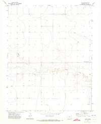
1971 Map of Lycan
USGS Topo · Published 1973About this map
Lycan and its surrounding high plains ranching country are documented here during the early 1970s. The landscape is defined by the ephemeral drainages of Buffalo Creek and Beaty Creek, which cut through the level terrain just five miles west of the Kansas border. This era shows the geographic shift of the local post office from the northern settlement to Buckeye Crossroads (Lycan PO) further south along the highway. Evidence of the vital underground water economy is scattered across the township lines in the form of numerous Well sites, which supported the homesteads and livestock operations in this corner of Baca County. The southern edge of the quadrangle includes the small community of Buckeye, illustrating the sparse but persistent settlement pattern of the Colorado plains.
Find a feature on this map
8 named features on this map. Tap any name to fly to it.
Don’t see what you’re looking for? This feature index may not catch every label — zoom into the map to look around manually.
Map Details
Editions of this 1971 Lycan Map
This is the sole edition of this map. No revisions or reprints were ever made.
Other maps of this area

1891 · Albany
USGS Topo · 1:125,000

1892 · Vilas
USGS Topo · 1:125,000

1893 · Albany
USGS Topo · 1:125,000

1955 · La Junta
USGS Topo · 1:250,000

1958 · La Junta
USGS Topo · 1:250,000

1968 · La Junta
USGS Topo · 1:250,000
1971 · Lycan SE
USGS Topo · 1:24,000
1971 · Lycan NE
USGS Topo · 1:24,000
1971 · Plains Community
USGS Topo · 1:24,000

1971 · Two Buttes SE
USGS Topo · 1:24,000