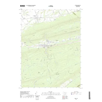
2019 Map of Lykens
USGS Topo · Published 2019About this map
Gratz and Lykens anchor this study of the anthracite-rich valleys of central Pennsylvania. The map illustrates a dense concentration of historical burial grounds within the boroughs, reflecting the complex social and religious fabric of the mining era, including the German Catholic Cem, Irish Catholic Cem, and the Patriotic Order Sons of America Cem. The terrain is defined by the massive ridges of Short Mtn and Big Lick Mtn, which frame the Wiconisco Creek corridor. Between these peaks, the landscape transition is sharp, moving from the grid-aligned streets of Wiconisco to the wild, water-carved slopes of Berry Mtn. Significant water features like Rattling Creek and Bear Swamp reveal the drainage patterns of the Broad Mountain plateau, while old mountain trails such as Lukes Trl and Hanover Trail Rd suggest the early routes used to navigate this ridge-and-valley system.
Find a feature on this map
93 named features on this map. Tap any name to fly to it.
Don’t see what you’re looking for? This feature index may not catch every label — zoom into the map to look around manually.
Map Details
Editions of this 2019 Lykens Map
This is the sole edition of this map. No revisions or reprints were ever made.
Other maps of this area

1892 · Lykens
USGS Topo · 1:62,500

1892 · Hummelstown
USGS Topo · 1:62,500

1892 · Harrisburg
USGS Topo · 1:62,500

1893 · Lykens
USGS Topo · 1:62,500

1893 · Millersburg
USGS Topo · 1:62,500

1899 · Harrisburg
USGS Topo · 1:62,500

1924 · Hummelstown
USGS Topo · 1:62,500

1924 · Harrisburg
USGS Topo · 1:62,500

1943 · Millersburg
USGS Topo · 1:62,500

1943 · Lykens
USGS Topo · 1:62,500