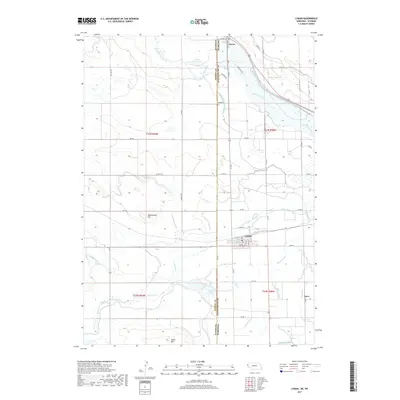
2017 Map of Lyman
USGS Topo · Published 2017About this map
Lyman sits at the heart of this agricultural borderland, where the Nebraska-Wyoming state line bisects the high plains. The landscape is defined by an intricate network of irrigation engineering required to water the valley, including the Mitchell and Gering Canal, Tri-State Canal, and Packer Ditch. These waterways support the rural settlements of Henry and Sears alongside the North Platte River, which snakes across the northern edge of the map. Elevated terrain such as Rattlesnake Hill and Table Mtn provide vertical contrast to the drainage basins of McElhaney Drain and Centennial Creek. The grid of county roads and the presence of local features like Packer Lake and Little Moon Lake illustrate the transition from open range to a structured, water-dependent farming community. This map offers a clear view of the hydraulic systems that made permanent settlement possible in this arid corridor of Scotts Bluff County.
Find a feature on this map
59 named features on this map. Tap any name to fly to it.
Don’t see what you’re looking for? This feature index may not catch every label — zoom into the map to look around manually.
Map Details
Editions of this 2017 Lyman Map
This is the sole edition of this map. No revisions or reprints were ever made.
Other maps of this area

1896 · Patrick
USGS Topo · 1:125,000

1898 · Scotts Bluff
USGS Topo · 1:125,000

1899 · Goshen Hole
USGS Topo · 1:125,000

1899 · Whistle Creek
USGS Topo · 1:125,000

1954 · Scottsbluff
USGS Topo · 1:250,000

1954 · Torrington
USGS Topo · 1:250,000

1954 · Cheyenne
USGS Topo · 1:250,000

1955 · Alliance
USGS Topo · 1:250,000

1957 · Alliance
USGS Topo · 1:250,000

1958 · Cheyenne
USGS Topo · 1:250,000