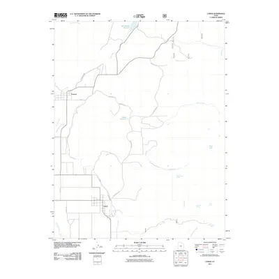
2011 Map of Lyman
USGS Topo · Published 2011About this map
The Lyman and Fremont communities are the focal points of this 2011 survey, illustrating the complex relationship between high-altitude settlement and water management in rural Utah. The landscape is defined by its sophisticated irrigation infrastructure, including the High Line Ditch and Fremont Loa Ditch, which redirect water from the Fremont River to sustain local agriculture. Higher elevations reveal numerous water sources like Bare Spot Spring and Saddle Pass Spring, while larger bodies such as Mill Meadow Reservoir and the high-mountain Blind Lake suggest a region shaped by both natural hydrology and engineered water storage. The road network, including Horse Valley Rd and various iterations of Horrock's Ln, traces the historical paths between ranches and reservoirs. Genealogists and local historians can use the precise placement of these ditches and rural lanes to locate family landholdings and understand the logistical layout of these communities in the early 21st century.
Find a feature on this map
27 named features on this map. Tap any name to fly to it.
Don’t see what you’re looking for? This feature index may not catch every label — zoom into the map to look around manually.
Map Details
Editions of this 2011 Lyman Map
This is the sole edition of this map. No revisions or reprints were ever made.
Other maps of this area

1885 · Fish Lake
USGS Topo · 1:250,000

1896 · Fish Lake
USGS Topo · 1:250,000

1952 · Notom 2 NW
USGS Topo · 1:24,000

1952 · Loa 1 SE
USGS Topo · 1:24,000

1952 · Notom 2 SW
USGS Topo · 1:24,000

1952 · Torrey
USGS Topo · 1:62,500

1952 · Loa 1 NE
USGS Topo · 1:24,000

1956 · Salina
USGS Topo · 1:250,000

1960 · Salina
USGS Topo · 1:250,000

1962 · Salina
USGS Topo · 1:250,000