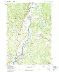
1981 Map of Lyme
USGS Topo · Published 1989About this map
The Connecticut River serves as the central artery and state boundary for this region, winding through a landscape of hills and valley settlements in the early 1980s. On the Vermont side, the Boston and Maine railroad tracks follow the river's western bank, connecting small communities like North Thetford and East Thetford. Significant institutional landmarks are present, including the Thetford Academy near Thetford Hill and the Barnes Sch further east.
Find a feature on this map
61 named features on this map. Tap any name to fly to it.
Don’t see what you’re looking for? This feature index may not catch every label — zoom into the map to look around manually.
Map Details
Editions of this 1981 Lyme Map
3 editions found
Other maps of this area

1896 · Strafford
USGS Topo · 1:62,500

1906 · Hanover
USGS Topo · 1:62,500

1908 · Hanover
USGS Topo · 1:62,500

1927 · Mascoma
USGS Topo · 1:62,500

1931 · Mt. Cube
USGS Topo · 1:62,500

1932 · Mascoma
USGS Topo · 1:62,500

1933 · Mt. Cube
USGS Topo · 1:62,500

1944 · Strafford
USGS Topo · 1:62,500

1950 · Glens Falls
USGS Topo · 1:250,000

1956 · Glens Falls
USGS Topo · 1:250,000