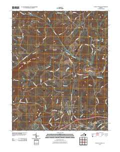
2010 Map of Lynch Station
USGS Topo · Published 2010About this map
Lynch Station and Evington anchor this portrait of Campbell County's interior, where the Big Otter River and Roanoke River systems converge. The landscape is defined by the prominent heights of Johnson Mountain, Scott Mountain, and Haden Mountain, which dictate the winding paths of rural roads like Leesville RD and Johnson Mountain RD. Local history is preserved in the placement of the Mount Hermon Cemetery and Vaughn Cemetery, serving as anchors for the surrounding residential growth in areas like Lakewood and Valley View Heights. The topography reveals a complex network of tributaries including Buffalo Creek, Orrix Creek, and Johnson Creek, illustrating the drainage patterns that have shaped the agricultural and residential development of this Virginia Piedmont region. This 2010 survey reflects the transition of traditional rail-adjacent settlements into modern residential corridors while maintaining their physical connection to the river valleys.
Find a feature on this map
58 named features on this map. Tap any name to fly to it.
Don’t see what you’re looking for? This feature index may not catch every label — zoom into the map to look around manually.
Map Details
Editions of this 2010 Lynch Station Map
This is the sole edition of this map. No revisions or reprints were ever made.
Other maps of this area

1892 · Lynchburg
USGS Topo · 1:125,000

1944 · Lynchburg
USGS Topo · 1:62,500

1947 · Roanoke
USGS Topo · 1:250,000

1950 · Goode
USGS Topo · 1:62,500

1950 · Lynchburg
USGS Topo · 1:62,500

1951 · Altavista
USGS Topo · 1:62,500

1956 · Gladys
USGS Topo · 1:62,500

1959 · Roanoke
USGS Topo · 1:250,000

1963 · Roanoke
USGS Topo · 1:250,000

1963 · City Farm
USGS Topo · 1:24,000