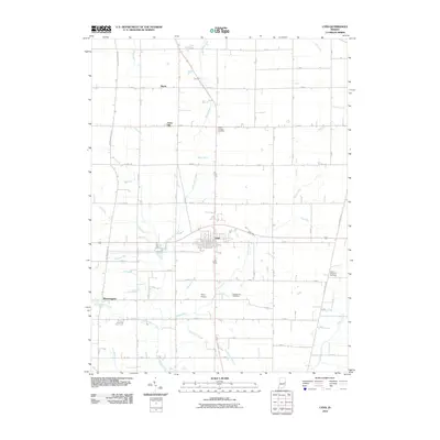
2010 Map of Lynn
USGS Topo · Published 2010About this map
The town of Lynn serves as the central hub of this eastern Indiana landscape, where a dense grid of rural roads connects agricultural homesteads and small settlements. To the northwest lies Rural, while the community of Bloomingport anchors the southwestern corner near Bloomingport Creek. This area is defined by a complex network of waterways, including the headwaters of the White River and numerous drainage features like Harshman Ditch and Hinshall Ditch, reflecting the region's managed hydraulic history. Local heritage is preserved at several burial grounds, such as Quaker Lynn Cemetery and Mount Gilliard Cemetery. The geography is relatively level, punctuated by the modest rise of Snow Hill and the small airfield at Pulley Airport. Researchers will find a meticulously surveyed landscape of section lines and family-named landmarks like Vandyke Run and Bell Run that trace the drainage patterns of the upper Greens Fork watershed.
Find a feature on this map
66 named features on this map. Tap any name to fly to it.
Don’t see what you’re looking for? This feature index may not catch every label — zoom into the map to look around manually.
Map Details
Editions of this 2010 Lynn Map
This is the sole edition of this map. No revisions or reprints were ever made.
Other maps of this area

1915 · New Paris
USGS Topo · 1:48,000

1916 · Winchester
USGS Topo · 1:48,000

1918 · Winchester
USGS Topo · 1:62,500

1918 · New Paris
USGS Topo · 1:62,500

1943 · Winchester
USGS Topo · 1:62,500

1952 · Maxville
USGS Topo · 1:24,000

1953 · Cincinnati
USGS Topo · 1:250,000

1953 · Muncie
USGS Topo · 1:250,000

1956 · Muncie
USGS Topo · 1:250,000

1957 · Cincinnati
USGS Topo · 1:250,000