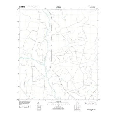
2011 Map of Macclenny NW
USGS Topo · Published 2011About this map
The Saint Marys River and its major tributaries define the character of this landscape on the Georgia-Florida border. The convergence of the North Prong Saint Marys River and the Middle Prong Saint Marys River marks a significant hydrological junction, while numerous smaller waterways such as Tiger Branch, Baker Branch, and Barber Branch drain the surrounding lowlands. This survey illustrates a rural region organized by a network of local roads named for established families, indicating a long-standing pattern of settlement and land ownership. These names, including Hassie Johns Rd, Noah Raulerson Rd, and Dave Brown Rd, provide valuable geographic context for those tracing local lineages. The road system, from County Hwy 120 to smaller routes like Seminole Ln, shows the modern infrastructure layered over the historical drainage basins of Bluff Creek and Sparkman Creek.
Find a feature on this map
39 named features on this map. Tap any name to fly to it.
Don’t see what you’re looking for? This feature index may not catch every label — zoom into the map to look around manually.
Map Details
Editions of this 2011 Macclenny NW Map
This is the sole edition of this map. No revisions or reprints were ever made.
Other maps of this area

1917 · Macclenny
USGS Topo · 1:62,500

1918 · Moniac
USGS Topo · 1:62,500

1918 · Macclenny
USGS Topo · 1:62,500

1942 · Moniac
USGS Topo · 1:62,500

1954 · Valdosta
USGS Topo · 1:250,000

1956 · Eddy
USGS Topo · 1:24,000

1958 · Valdosta
USGS Topo · 1:250,000

1959 · Valdosta
USGS Topo · 1:250,000
1966 · St George
USGS Topo · 1:24,000
1967 · Moniac
USGS Topo · 1:24,000