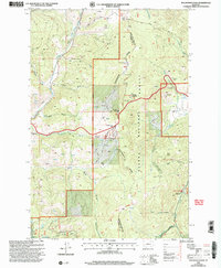
2001 Map of Macdonald Pass
USGS Topo · Published 2004About this map
The Continental Divide zigzags across this high-elevation landscape, marking the hydrological crest between the Helena National Forest and the Helena Ranger District. The map captures the intersection of recreation and utility, featuring the Scenic National Recreation Trail alongside infrastructure like the Cromwell-Dixon Pipeline and multiple Communication Sites. Human activity is concentrated around MacDonald Pass, where Frontier Town and Forest Heights sit near the summit, while Priest Pass Road provides an alternative crossing to the north.
Find a feature on this map
46 named features on this map. Tap any name to fly to it.
Don’t see what you’re looking for? This feature index may not catch every label — zoom into the map to look around manually.
Map Details
Editions of this 2001 Macdonald Pass Map
This is the sole edition of this map. No revisions or reprints were ever made.
Other maps of this area

1889 · Helena
USGS Topo · 1:250,000

1893 · Helena
USGS Topo · 1:250,000

1899 · Boulder
USGS Topo · 1:125,000

1899 · Helena
USGS Topo · 1:250,000

1903 · Helena
USGS Topo · 1:250,000

1947 · Butte
USGS Topo · 1:250,000

1950 · Jefferson City
USGS Topo · 1:62,500

1950 · Helena
USGS Topo · 1:62,500

1954 · Basin
USGS Topo · 1:62,500

1958 · Butte
USGS Topo · 1:250,000