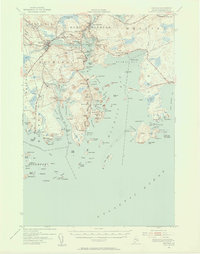
1941 Map of Machias
USGS Topo · Published 1956About this map
The Machias River and East Machias River converge in this coastal Maine landscape, where the maritime economy and early rail infrastructure define the local geography. The Maine Central RR cuts across the northern terrain, serving stops like Machiasport Sta and connecting the inland timber and fishing resources to the larger regional network. Along the shoreline, historical defensive sites like Fort O'Brien stand near the settlement of Machiasport, reflecting the strategic importance of this harbor during earlier eras.
Find a feature on this map
160 named features on this map. Tap any name to fly to it.
Don’t see what you’re looking for? This feature index may not catch every label — zoom into the map to look around manually.
Map Details
Editions of this 1941 Machias Map
Other maps of this area

1907 · Eastport
USGS Topo · 1:48,000

1908 · Eastport
USGS Topo · 1:62,500

1917 · Cutler
USGS Topo · 1:62,500

1918 · Machias
USGS Topo · 1:62,500

1918 · Cutler
USGS Topo · 1:62,500

1921 · Great Wass Island
USGS Topo · 1:62,500

1921 · Columbia Falls
USGS Topo · 1:62,500

1941 · Columbia Falls
USGS Topo · 1:62,500

1941 · Machias
USGS Topo · 1:62,500

1941 · Wesley
USGS Topo · 1:62,500