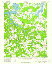
1943 Map of Machodoc
USGS Topo · Published 1961About this map
Nomini Creek and its complex network of inlets and coves dominate this mid-century view of the Northern Neck. The landscape is a mix of tidal marshes like Greens Marsh and high ground such as Prospect Hill, where the Tidewater topography transitions from the water's edge to inland agricultural and residential clusters. Small crossroads and hamlets like Mount Holly, Hague, and Nomini Grove are connected by a network of local roads crossing major water bodies at points like Nomini Bridge.
Find a feature on this map
76 named features on this map. Tap any name to fly to it.
Don’t see what you’re looking for? This feature index may not catch every label — zoom into the map to look around manually.
Map Details
Editions of this 1943 Machodoc Map
2 editions found
Other maps of this area

1892 · Piney Point
USGS Topo · 1:62,500

1892 · Montross
USGS Topo · 1:62,500

1894 · Piney Point
USGS Topo · 1:62,500

1895 · Nomini
USGS Topo · 1:125,000

1895 · Piney Point
USGS Topo · 1:62,500

1895 · Montross
USGS Topo · 1:62,500

1898 · Nomini
USGS Topo · 1:125,000

1901 · Piney Point
USGS Topo · 1:62,500

1917 · Morattico
USGS Topo · 1:62,500

1918 · Tappahannock
USGS Topo · 1:62,500