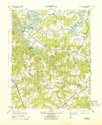
1943 Map of Machodoc
USGS Topo · Published 1943About this map
Nomini Hall stands as a central landmark in this mid-century survey of Westmoreland County, anchoring a landscape defined by the intricate tidal reaches of the Machodoc River and Nomini Creek. The map documents a transition from traditional waterfront commerce to inland agriculture, evidenced by Mcguires Wharf and various landings along Machodoc Neck contrasted with the established estates of Mt Pleasant Farm and Antioch Farm. Genealogists will find significant value in the documentation of the Lee Burial Plot and numerous rural congregations like Jerusalem Church and St Johns Ch. The presence of Knights Community Hall and the Cople Parish Ho near Hague suggests a tightly knit social fabric during the war years. Small crossroads such as Nomini Grove and Erica are meticulously mapped alongside topographic details like Beales Millpond and the George Washington Memorial Hwy.
Find a feature on this map
87 named features on this map. Tap any name to fly to it.
Don’t see what you’re looking for? This feature index may not catch every label — zoom into the map to look around manually.
Map Details
Editions of this 1943 Machodoc Map
2 editions found
Other maps of this area

1892 · Piney Point
USGS Topo · 1:62,500

1892 · Montross
USGS Topo · 1:62,500

1894 · Piney Point
USGS Topo · 1:62,500

1895 · Nomini
USGS Topo · 1:125,000

1895 · Piney Point
USGS Topo · 1:62,500

1895 · Montross
USGS Topo · 1:62,500

1898 · Nomini
USGS Topo · 1:125,000

1901 · Piney Point
USGS Topo · 1:62,500

1917 · Morattico
USGS Topo · 1:62,500

1918 · Tappahannock
USGS Topo · 1:62,500