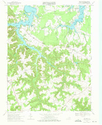
1968 Map of Machodoc
USGS Topo · Published 1971About this map
The deep estuaries of Lower Machodoc Creek and Nomini Creek dominate this 1960s landscape, reflecting a shoreline economy built on water access and tobacco-era landings. Historic points of commerce like Mc Guires Wharf and Beales Wharf are mapped along the winding banks of Nomini Creek, while the inland road network connects long-established crossroads such as Nomini Grove and Hinnom. The map captures a transition toward modern rural life, where local churches like St James Ch and Ebenezer Ch served as the primary anchors for dispersed farming communities.
Find a feature on this map
102 named features on this map. Tap any name to fly to it.
Don’t see what you’re looking for? This feature index may not catch every label — zoom into the map to look around manually.
Map Details
Editions of this 1968 Machodoc Map
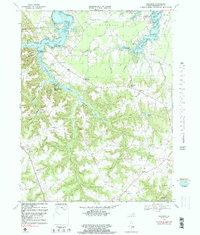
2 editions found
Other maps of this area

1892 · Piney Point
USGS Topo · 1:62,500

1892 · Montross
USGS Topo · 1:62,500

1894 · Piney Point
USGS Topo · 1:62,500

1895 · Nomini
USGS Topo · 1:125,000

1895 · Piney Point
USGS Topo · 1:62,500

1895 · Montross
USGS Topo · 1:62,500

1898 · Nomini
USGS Topo · 1:125,000

1901 · Piney Point
USGS Topo · 1:62,500

1917 · Morattico
USGS Topo · 1:62,500

1918 · Tappahannock
USGS Topo · 1:62,500