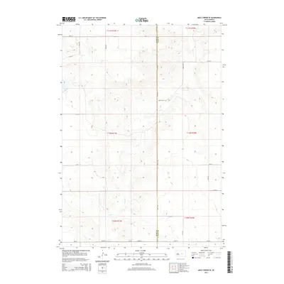
2015 Map of Macs Corner SE
USGS Topo · Published 2015About this map
Hyde and Hand Counties meet along a sharp North-South boundary in this high-plains landscape, characterized by the winding drainage of Elm Cr. The terrain is defined by wide-spaced section-line roads, such as 344th Ave and 213th St, which trace a rigid grid across the undulating topography. This 2015 survey reflects a deeply rural agricultural district where land use is structured by the Public Land Survey System, as evidenced by the township and range divisions like t110n r71w. Local transit is facilitated by secondary routes like Green Valley Rd and Cr-776, connecting isolated farmsteads and fields to the broader region. The lack of concentrated settlements highlights the sparse, expansive nature of this part of the Dakotas, where the natural course of Elm Cr remains the most prominent geological feature amidst the human-imposed geometry of the township grid.
Find a feature on this map
22 named features on this map. Tap any name to fly to it.
Don’t see what you’re looking for? This feature index may not catch every label — zoom into the map to look around manually.
Map Details
Editions of this 2015 Macs Corner SE Map
This is the sole edition of this map. No revisions or reprints were ever made.
Other maps of this area

1953 · Huron
USGS Topo · 1:250,000

1954 · Huron
USGS Topo · 1:250,000

1966 · Big Bend Dam NE
USGS Topo · 1:24,000

1966 · Stephan
USGS Topo · 1:24,000

1973 · Macs Corner NE
USGS Topo · 1:24,000

1973 · Miller Dale Colony SW
USGS Topo · 1:24,000

1973 · Big Bend Dam 4 NW
USGS Topo · 1:24,000

1973 · Macs Corner SE
USGS Topo · 1:24,000
1973 · Miller Dale Colony NW
USGS Topo · 1:24,000

1973 · Macs Corner
USGS Topo · 1:24,000