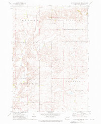
1973 Map of Miller Dale Colony NW
USGS Topo · Published 1976About this map
The Old Indian Treaty Boundary cuts across the southwestern corner of this Hand County landscape, marking a significant historical line through the prairie. In the early 1970s, this area of South Dakota was characterized by vast agricultural sections and the distinctive upland features of Ree Heights and Midland. The terrain is punctuated by small-scale industrial and utility markers, including several Gravel Pits and prominent Radio Towers. Water management is a visible priority for these rural townships, evidenced by the presence of a Flowing Well and numerous individual Wells scattered across the township lines. The survey also captures the named districts of Spring Hill and Rock Dale, providing a clear view of the rural settlement pattern and land-use divisions during this era.
Find a feature on this map
10 named features on this map. Tap any name to fly to it.
Don’t see what you’re looking for? This feature index may not catch every label — zoom into the map to look around manually.
Map Details
Editions of this 1973 Miller Dale Colony NW Map
This is the sole edition of this map. No revisions or reprints were ever made.
Other maps of this area

1950 · Ree Heights SE
USGS Topo · 1:24,000

1950 · Ree Heights
USGS Topo · 1:24,000

1950 · Highmore SE
USGS Topo · 1:24,000

1953 · Huron
USGS Topo · 1:250,000

1954 · Huron
USGS Topo · 1:250,000

1973 · Ames
USGS Topo · 1:24,000

1973 · Macs Corner NE
USGS Topo · 1:24,000

1973 · Miller Dale Colony SW
USGS Topo · 1:24,000

1973 · Macs Corner SE
USGS Topo · 1:24,000
1973 · Miller Dale Colony
USGS Topo · 1:24,000