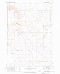
1973 Map of Miller Dale Colony
USGS Topo · Published 1976About this map
Miller Dale Colony serves as a primary point of interest in this Hand County landscape, which is largely defined by its township boundaries including Midland, Miller, Rockdale, and Logan. The map illustrates a characteristic Great Plains settlement pattern where Hutterite colonies and localized encampments like Camp Da-Ko-Ta are established amid expansive agricultural sections. Water management and natural drainage are evident through features such as Collins Slough and various wells, which were vital for sustaining the communal farming lifestyle of the area. A small Cem and scattered Gravel Pit locations indicate the local necessities of rural life, from infrastructure materials to the community's ancestral grounds. The topography consists of low-lying depressions and subtle rises, typical of the glaciated plains in South Dakota.
Find a feature on this map
10 named features on this map. Tap any name to fly to it.
Don’t see what you’re looking for? This feature index may not catch every label — zoom into the map to look around manually.
Map Details
Editions of this 1973 Miller Dale Colony Map
This is the sole edition of this map. No revisions or reprints were ever made.
Other maps of this area

1899 · Redfield
USGS Topo · 1:125,000

1949 · Vayland SW
USGS Topo · 1:24,000

1950 · Ree Heights SE
USGS Topo · 1:24,000

1950 · Vayland NW
USGS Topo · 1:24,000

1950 · Ree Heights
USGS Topo · 1:24,000

1951 · Vayland SW
USGS Topo · 1:24,000

1953 · Huron
USGS Topo · 1:250,000

1954 · Huron
USGS Topo · 1:250,000

1967 · Miller
USGS Topo · 1:24,000

1973 · Ames
USGS Topo · 1:24,000