
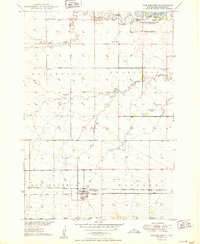
1950 Map of Ree Heights
USGS Topo · Published 1950About this map
Ree Heights serves as the focal point of this mid-century survey of Hand County, situated along the Chicago and North Western railroad line. The settlement's layout is clearly defined, with the nearby Morningside Cem located just to the south. The landscape is characterized by a network of seasonal waterways including Wolf Creek, Little Wolf Creek, and Turtle Cr, which traverse the prairie terrain. To the northeast, the Lake Louise Recreational Area and Wildlife Refuge surrounds Lake Louise, indicating the importance of water management and conservation in this region. This era of South Dakota history is further documented through the locations of rural schoolhouses like Steptoe Sch and Center Sch, which were central to the scattered farming communities. The presence of numerous Flowing Wells and Windmills across the townships highlights the ongoing reliance on groundwater for agriculture and livestock in the Missouri River Basin development area.
Find a feature on this map
19 named features on this map. Tap any name to fly to it.
Don’t see what you’re looking for? This feature index may not catch every label — zoom into the map to look around manually.
Map Details
Editions of this 1950 Ree Heights Map
2 editions found
Other maps of this area

1949 · Ree Heights NW
USGS Topo · 1:24,000

1950 · Ree Heights SE
USGS Topo · 1:24,000

1950 · Highmore NE
USGS Topo · 1:24,000

1950 · Highmore SE
USGS Topo · 1:24,000

1951 · Ree Heights NW
USGS Topo · 1:24,000

1951 · Ree Heights NE
USGS Topo · 1:24,000

1953 · Huron
USGS Topo · 1:250,000

1954 · Huron
USGS Topo · 1:250,000

1973 · Macs Corner NE
USGS Topo · 1:24,000
1973 · Miller Dale Colony NW
USGS Topo · 1:24,000